Le Bois-Plage-en-Ré
Le Bois-Plage-en-Ré | |
|---|---|
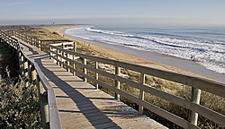
 Plaża w Le Bois-Plage-en-Ré
| |
| Współrzędne: Współrzędne : | |
| Kraj | Francja |
| Region | Nowa Akwitania |
| Dział | Charente-Maritime |
| Dzielnica | La Rochelle |
| Kanton | Île de Ré |
| Międzygminność | Île de Ré |
| Rząd | |
| • Burmistrz (2020–2026) | Gérarda Juina |
| Obszar 1
|
12,18 km2 (4,70 2 ) |
| Populacja
(styczeń 2019)
|
2272 |
| • Gęstość | 190/km2 ( 480/2) |
| Strefa czasowa | UTC+01:00 ( CET ) |
| • Lato ( DST ) | UTC+02:00 ( CEST ) |
| INSEE /Kod pocztowy |
17051 /17580 |
| Podniesienie |
1–17 m (3,3–55,8 stopy) (średnio 11 m lub 36 stóp) |
| 1 Dane z francuskiego rejestru gruntów, które wykluczają jeziora, stawy, lodowce > 1 km 2 (0,386 2 lub 247 akrów) i ujścia rzek. | |
[lə bwa plaʒ ɑ̃ ʁe] Le Bois-Plage-en-Ré ( wymowa francuska: <a i=3>[ ) to gmina w departamencie Charente-Maritime w regionie Nouvelle-Aquitaine w południowo-zachodniej Francji . Znajduje się na Île de Ré .
Populacja
|
|
||||||||||||||||||||||||||||||||||||||||||||||||||||||||||||||||||||||||||||||||||||||||||||||||||||||||||||||||||
| Źródło: EHESS i INSEE (1968-2017) | |||||||||||||||||||||||||||||||||||||||||||||||||||||||||||||||||||||||||||||||||||||||||||||||||||||||||||||||||||
Zobacz też
Linki zewnętrzne
-
 Media związane z Le Bois-Plage-en-Ré w Wikimedia Commons


