Saint-Christophe-en-Boucherie
Saint-Christophe-en-Boucherie | |
|---|---|
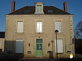
 Ratusz w Saint-Christophe-en
| |
| Współrzędne: Współrzędne : | |
| Kraj | Francja |
| Region | Centre-Val de Loire |
| Dział | Ind |
| Dzielnica | La Châtre |
| Kanton | La Châtre |
| Rząd | |
| • Burmistrz (2020–2026) | Jeana-Luca Mançois |
| Obszar 1
|
26,89 km2 ( 10,38 2) |
| Populacja
(styczeń 2019)
|
256 |
| • Gęstość | 9,5/km 2 (25/2) |
| Strefa czasowa | UTC+01:00 ( CET ) |
| • Lato ( DST ) | UTC+02:00 ( CEST ) |
| INSEE /Kod pocztowy |
36186 /36400 |
| Podniesienie |
191–274 m (627–899 stóp) (średnio 268 m lub 879 stóp) |
| 1 Dane z francuskiego rejestru gruntów, które wykluczają jeziora, stawy, lodowce > 1 km 2 (0,386 2 lub 247 akrów) i ujścia rzek. | |
[sɛ̃ kʁistɔf ɑ̃ buʃʁi] Saint-Christophe-en-Boucherie ( wymowa francuska: <a i=3>[ ) to gmina w departamencie Indre w środkowej Francji .
Populacja
|
|
Zobacz też
Kategorie:


