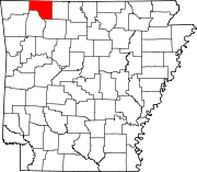
Cedar Township, Carroll County, Arkansas
Cedar Township | |
|---|---|
| Współrzędne: Współrzędne : | |
| Kraj |
|
| Państwo |
|
| Hrabstwo | Carrolla |
| Obszar | |
| • Całkowity | 35,742 mil kwadratowych (92,57 km2 ) |
| • Grunt | 35,734 mil kwadratowych (92,55 km2 ) |
| • Woda | 0,008 mil kwadratowych (0,02 km2 ) |
| Podniesienie | 1178 stóp (359 m) |
| Populacja
( 2010 )
| |
| • Całkowity | 3575 |
| • Gęstość | 78,90 na milę kwadratową (30,46 na kilometr kwadratowy ) |
| Strefa czasowa | UTC-6 ( CST ) |
| • Lato ( DST ) | UTC-5 ( CDT ) |
| Kod pocztowy | 72631-72632 ( Eureka Springs ) |
| Numer kierunkowy | 479 |
| Identyfikator elementu GNIS | 66892 |
Cedar Township jest jednym z dwudziestu jeden obecnych miasteczek w Carroll County , Arkansas , USA . Według spisu z 2010 roku całkowita liczba ludności wynosiła 3575.
Geografia
Według United States Census Bureau , Cedar Township zajmuje powierzchnię 35.742 mil kwadratowych (92,57 km2 ) ; 35,734 mil kwadratowych (92,55 km2 ) lądu i 0,008 mil kwadratowych (0,021 km2 ) wody.
Miasta, miasteczka i wsie
- Eureka Springs (część)
- United States Census Bureau 2008 TIGER/Line Shapefiles
- Spis powszechny 2010 US Gazetteer Files: Podziały hrabstw w Arkansas
Linki zewnętrzne

